Showing posts with label aerial. Show all posts

Friday, April 20, 2018

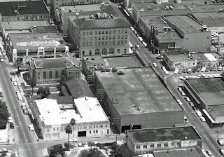
1969 Fort Brown and downtown Brownsville, Texas aerial views

 1969 August aerial photo Brownsville, Texas
 Immaculate Conception Cathedral (top left- E Jefferson and 12th St) and Market Square / Town Hall (right center) with Fire Station No1 on E Adams and 10th (bottom right) 
 Texas Southmost College Library and Gorgas building and many Fort Brown buildings (top center) with Immaculate Conception Cathedral at bottom center
 Fort Brown Motor Hotel surrounded by Horseshoe Lake with Jacob Brown Memorial Center at center.  The infamous Casa de Nylon (bottom left) and Customs - right center
 A closer look at Market Square / Town Hall and surrounding buildings
 From top center to right - King Mart and International Bridge to Matamoros, Tamaulipas, Mexico.  There are many recognizable buildings downtown-- no need to name them all.
 Entrance to Matamoros and El Jardon Hotel at bottom center.
Coca Cola building, Methodist Church, Cameron County Courthouse / Post Office across the street from The Majestic Theater on E Elizabeth and 10th
The Vivier Opera House and Goodyear Tires Servive buildings are gone from E Levee and 10th as is the Sinclair gas station (top center).  They called that tall building the Pan-Am Bank at the time maybe ... It is now used for Cameron County offices

Please send any corrections or add your additional comments below 

Friday, October 30, 2015

1969 Aerial maps of Boca Chica and Expressway 77


August 08, 1969 aerial photo sections courtesy of Brownsville Historical Association

Friday, August 7, 2015

1962 ~ Aerials of The Star, Charro and Ruenes Drive-ins

The lot of what was once the Star Drive in and Mauldin Airport above it.  The privately owned Star opened in 1946 but sold to Ezell & Associates who opened the Charro in 1949.  Although it underwent upgrades it eventually closed around 1952.  This is where McAllen Rd meets with Morrison Rd and old Hwy 77.  There are several banks there now with Academy Sports close-by.  The screen and lot would be south of the banks.  The original manager Marshall C. Nichols told me the screen tower had been torn down in the mid 1950s and tall poles donated to hold lights for the TSC Baseball field.
The Charro and H-E-B / Gulf Mart (?).  The Buena Vista Cemetery on left and section of McDavitt St. housing on the right.  The screen might have been where the northwest corner of Dollar Tree building is today.  It closed around the late 1970s or early 80's?
The Fiesta Drive was built in 1954 and became the Ruenes Drive-in by 1965; lasting until c1990. Here it was still the Fiesta which showed Spanish and English language movies.  The Southmost 
H-E-B is there today and Cromack Elementary is where it always was.

Download maps if that makes easier to view street names.  This also looks great on your phone. Thanks to Erick Randall Tripp for sending me on this awesome search on Google Earth!